Saturday, October 21, 2006

Guye Peak, WA - Last Rock for the Year

The Improbable Traverse on Guye Peak has been described as one of the closest and most accessible alpine climbs in the vicinity of Seattle. With the days getting shorter and the air cooling we found ourselves with one more weekend of climbing weather in the PNW.

Located close to Interstate 90 in Snoqualmie Pass the mountain is one of the lower ones in the pass but casts a striking profile with a classic pyramid shape. The steep west face is the most appealing face of Guye Peak and has one or two pitches of high-quality climbing on clean rock that makes the doing all the pitches worthwhile. The approach is made via a steep scree field below the west face of the peak and that is where we started. The early pitches are a bit rotten at best but the traverse is airy and fully enjoyable nonetheless. The climb ends a bit prematurely after the ramp but the summit views and blocks make for good scrambling.


Dave Loading his Gear

Dave loading his gear out of Big Red

Looking up the scree field to the west face


Improbable Traverse Route

Scree Monster


1st Roped Pitch

1st pitch done


Dave Arriving at Lunch Ledge
Dave arrives at Lunch Ledge


Getting some gear in under the roof
This is the start of the classic section of the route


The Improbable Traverse
Mid way on the airy "Improbable" traverse


Stretching out a 50m for a single pitch
Hard to see but follow the rope line across the wall and you'll find me tucked in the corner


It's Tetly Tea Time and yes Helium filled cans do float away!


Pond Near Summit
Reflection Pond near the summit


A great view of the ramp feature looking northwards

Saturday, October 14, 2006

Index ,WA - Davis Holland Route

The best time to climb at Index is in the late summer and fall when the routes are dried out. The Davis-Holland route is located on the Upper Wall and is an Index classic going at 10c with about 3-6 pitches depending on how far one wants to climb into deteriorating rock. Michael and I enjoyed our day outing at Index with a bit of harder sport climbing earlier in the day and then a hike to the upper wall and a run on this fine trad line. I feel this is one of the best lines at Index but I would recommend the right variation to the start of the 3rd pitch.


Davis-Holland P1

Starting up the route


Davis-Holland P2a Tch

Coming up pitch 2 - looks like a pretty big wall


Davis-Holland P2b

Good jamm'in


Davis-Holland P2d


Davis-Holland P2i

Cracked up - note Michael's silouette


Grand MC w Mt. Barring in the back

Michael, the Town of Index and Mt. Barring in the background

Monday, August 21, 2006

Mt.Pilchuck, WA - More a Hike Less a Climb

Mount Pilchuck is in a WA State Park which covers about 1,893-acres. The main recreational attraction of the park is the three-mile trail to the summit and the old fire lookout. The trail begins at 3100 feet and winds through an old growth forest to alpine heather and large rocks at the summit of Mount Pilchuck ~5324 feet. The top provides incredible panoramic views of the Cascades, Olympics and Puget Sound.

Since Laurie was visiting and this gorgeous summer day provided a crystal clear sky we decided this would be a most enjoyable outing. Vena and Mary-Lou joined in for the hike and as usual the little antelope beat us all to the summit.

Trouble, trouble and more trouble


Laurie's 9th visit to Seattle?


Beautiful vistas


Pilchuck's Rock Gardens


Who is this hottie?


Hanging out at the fire lookout

Wednesday, July 26, 2006

14,410 feet, WA - Mount Rainier

Ring, ring..."Michael I think the weather is looking good mid-week, think you can get a day or two and we'll take a run on Rainier?" Sure thing Michael said and we met up Wednesday morning to head out for our climb with the plan to have Michael back at home Thursday evening. As you can see from the pictures, the weather was perfect and the climb went without a hitch. We tried to go light but one can never tell on a 14,000+ ft peak what will happen so regardless we still had relatively large packs. The one thing that Michael stressed was taking the most casual pace to the base camp at Ingram Flats ~11,000 ft to minimize lactic acid build-up in the legs and provide us with the best option to summit the next morning. We got our permits from the Paradise Visitor Center Ranger Station (~5,500 ft) and around 11:30am started our slow ascent to high camp. Our first goal would be Camp Muir at ~ 10,000 ft and Michael reeled me in more than once to slow my pace. Every 1000 ft we drank and then alternated having a small snack or bite every other 1000 ft. It worked well and when we reached Camp Muir I was not feeling the least bit tired. We munched a bit more and continued on this time roped up due to the crevasse danger on the Cowlitz Glacier after Camp Muir. We also dawned our helmets to minimize getting pinged by small rock fall from the wall before Ingram Flats.


Wild flowers and ideal weather


Michael ready to roll


"Smallish" packs & a Coke to get stashed in Pebble Creek - cold & refreshing for the way down


Let's get serious


Passing Pebble Creek - we also stashed our approach shoes here and went to plastics

Michael pacing the Muir Snowfield


Boot penetration wasn't too bad but it was hot in the noon sun


Cathedral Gap - below this section sits the Cowlitz Glacier which is just above Camp Muir

Arriving at Ingram Flats ~11,000 ft


Home sweet home and time to get in our bivi sacs


Michael was chef and head water boiler


Looking down at camp from higher up the Ingram


We awoke a couple of times and watched the line of headlamps from the RMI guided group coming up the Ingram like a train of ants. That was about 2am. We got up around 5am with the sun and decided to pack our camp in a hole we dug in the snow in case it got windy. The ascent was event less and we made the summit by 9ish. After a few pictures and exploration we made a fast descent and caught the RMI group before DC. When we reached camp Michael had a bit of a dehydration headache so he built a shade shelter, Tylenol'd up and had a nappy while I prepped food for a refuel and our eventual departure for Paradise.


Sunrise comes early


Not a super early start but we'll move fast!


Getting on to Disappointment Clever


A nice view of Mt. Adams from the top of Disappointment Clever ~12,300 ft


Coming up the trough/climbers path


Feeling strong and keeping up a good pace
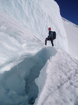


Crevasse obstacles and objective dangers - note that snow bridges fail in warm weather


Another party assessing the crevasse


...and on and on it goes...the air thinning all the time


Finally we are in the summit crater and heading to the summit high point ~1/4 mile across the crater


The Columbia Crest on the western rim is the true summit


The highest man in Washington State - 14,410 feet


On the way down we caught up and passed the large RMI party


Back at Ingram - nappy time while I made soup and tea


Our final descent was made all that much better when we recovered those icy cold Cokes from Pebble Creek and swapped our heavy boots for approach shoes. We had gone from Seattle to the summit in under 24 hours and back down to the car in about 27 hours round trip. Great trip, thanks Michael!